Subset SWOT LR L2 Unsmoothed data from AVISO’s FTP Server
This notebook explains how to select and retrieve Unsmoothed (250-m) SWOT LR L2 half orbits from AVISO’s FTP Server, and subset data with a geographical area.
L2 Unsmoothed data can be explored at:
You need to have xarray, numpy, pydap, threddsclient and matplotlib+cartopy (for visualisation) packages installed in your Python environment to execute this notebook.
Tutorial Objectives
Download files through FTP, with selection by cycle and pass numbers
Subset data with geographical selection
Import + code
[1]:
# Install Cartopy with mamba to avoid discrepancies
# ! mamba install -q -c conda-forge cartopy
[2]:
import warnings
warnings.filterwarnings('ignore')
[3]:
import os
from getpass import getpass
import numpy as np
import ftplib
import xarray as xr
[4]:
import cartopy.crs as ccrs
import matplotlib.pyplot as plt
[5]:
def _download_file(ftp:str, filename:str, target_directory:str):
    print(f"Download file: {filename}")
    try:
        local_filepath = os.path.join(target_directory, filename)
        with open(local_filepath, 'wb') as file:
            ftp.retrbinary('RETR %s' % filename, file.write)
            return local_filepath
    except Exception as e:
        print(f"Error downloading {filename}: {e}")

def _get_last_version_filename(filenames):
    versions = {int(f[-5:-3]): f for f in filenames}
    return versions[max(versions.keys())]

def _select_filename(filenames, only_last):
    if not only_last: return filenames
    return [_get_last_version_filename(filenames)]

def ftp_download_files(ftp_path, level, variant, cycle_numbers, half_orbits, output_dir, only_last=True):
    """ Download half orbits files from AVISO's FTP Server.
    Args:
        ftp_path
            path of the FTP fileset
        level
            L2 or L3
        variant
            Basic, Expert, WindWave or Unsmoothed
        cycle_numbers
            list of cycles numbers
        half_orbits
            list of passes numbers
        output_dir
            output directory
        only_last
            if True (Default), downloads only the last version of a file if several versions exist.
            Downloads all versions otherwise.
    Returns:
        The list of local files.
    """
    # Set up FTP server details
    ftpAVISO = 'ftp-access.aviso.altimetry.fr'
    try:
        # Logging into FTP server using provided credentials
        with ftplib.FTP(ftpAVISO) as ftp:
            ftp.login(username, password)
            ftp.cwd(ftp_path)
            print(f"Connection Established {ftp.getwelcome()}")
            downloaded_files = []

            for cycle in cycle_numbers:
                cycle_str = '{:03d}'.format(cycle)
                cycle_dir = f'cycle_{cycle_str}'
                print(ftp_path+cycle_dir)
                ftp.cwd(cycle_dir)

                for half_orbit in half_orbits:
                    half_orbit_str = '{:03d}'.format(half_orbit)
                    pattern = f'SWOT_{level}_LR_SSH_{variant}_{cycle_str}_{half_orbit_str}'
                    filenames = []
                    try:
                        filenames = ftp.nlst(f'{pattern}_*')
                        # No version in L3 filenames
                        if level=="L3": only_last=False
                        filenames = _select_filename(filenames, only_last)
                    except Exception as e:
                        print(f"No pass {half_orbit}")

                    local_files = [_download_file(ftp, f, output_dir) for f in filenames]
                    downloaded_files += local_files

                ftp.cwd('../')

            return downloaded_files

    except ftplib.error_perm as e:
        print(f"FTP error: {e}")
    except Exception as e:
        print(f"Error: {e}")

def _normalized_ds(ds, lon_min, lon_max):
    lon = ds.longitude.values
    lon[lon < lon_min] += 360
    lon[lon > lon_max] -= 360
    ds.longitude.values = lon
    return ds

def _subset_ds(file, group, variables, lon_range, lat_range):
    swot_ds = xr.open_dataset(file, group=group)
    swot_ds = swot_ds[variables]
    swot_ds.load()

    ds = _normalized_ds(swot_ds.copy(), -180, 180)

    mask = (
        (ds.longitude <= lon_range[1])
        & (ds.longitude >= lon_range[0])
        & (ds.latitude <= lat_range[1])
        & (ds.latitude >= lat_range[0])
    ).compute()

    swot_ds_area = swot_ds.where(mask, drop=True)

    for var in list(swot_ds_area.keys()):
        swot_ds_area[var].encoding = {'zlib':True, 'complevel':5}

    return swot_ds_area

def _to_netcdf(ds_root, ds_left, ds_right, output_file):
    """ Writes the dataset to a netcdf file """
    ds_root.to_netcdf(output_file)
    ds_right.to_netcdf(output_file, group='right', mode='a')
    ds_left.to_netcdf(output_file, group='left', mode='a')

def _subset_grouped_ds(file, variables, lon_range, lat_range, output_dir):
    print(f"Subset dataset: {file}")
    ds_root = xr.open_dataset(file)
    swot_ds_right = _subset_ds(file, 'right', variables, lon_range, lat_range)
    swot_ds_left = _subset_ds(file, 'left', variables, lon_range, lat_range)

    if swot_ds_right.sizes['num_lines'] == 0 and swot_ds_left.sizes['num_lines'] == 0:
        print(f'Dataset {file} not matching geographical area.')
        return None

    filename = f"subset_{os.path.basename(file)}"

    print(f"Store subset: {filename}")
    filepath = os.path.join(output_dir, filename)

    _to_netcdf(ds_root, swot_ds_left, swot_ds_right, filepath)

    return filepath

def subset_files(filenames, variables, lon_range, lat_range, output_dir):
    """ Subset datasets with geographical area.
    Args:
        filenames
            the filenames of datasets to subset
        variables
            variables to select
        lon_range
            the longitude range
        lat_range
            the latitude range
        output_dir
            output directory
    Returns:
        The list of subsets files.
    """
    return [subset_file for subset_file in [_subset_grouped_ds(f, variables, lon_range, lat_range, output_dir) for f in filenames] if subset_file is not None]

def _interpolate_coords(ds):
    lon = ds.longitude
    lat = ds.latitude
    shape = lon.shape
    lon = np.array(lon).ravel()
    lat = np.array(lat).ravel()
    dss = xr.Dataset({
        'longitude': xr.DataArray(
                    data   = lon,
                    dims   = ['time']
                    ),
        'latitude': xr.DataArray(
                    data   = lat,
                    dims   = ['time'],
                    )
                },)
    dss_interp = dss.interpolate_na(dim="time", method="linear", fill_value="extrapolate")
    ds['longitude'] = (('num_lines', 'num_pixels'), dss_interp.longitude.values.reshape(shape))
    ds['latitude'] = (('num_lines', 'num_pixels'), dss_interp.latitude.values.reshape(shape))

def normalize_coordinates(ds):
    """ Normalizes the coordinates of the dataset : interpolates Nan values in lon/lat, and assign lon/lat as coordinates.
    Args:
        ds: the dataset

    Returns:
        xr.Dataset: the normalized dataset
    """
    _interpolate_coords(ds)
    return ds.assign_coords(
            {"longitude": ds.longitude, "latitude": ds.latitude}
        )
Parameters
Define existing output folder to save results:
[6]:
output_dir = "downloads"
Authentication parameters
Enter your AVISO+ credentials
[7]:
username = input("Enter username:")
Enter username: aviso-swot@altimetry.fr
[10]:
password = getpass(f"Enter password for {username}:")
Enter password for aviso-swot@altimetry.fr: ········
Data parameters
Define the variables you want:
[11]:
variables = ['latitude', 'longitude', 'time', 'sig0_karin_2', 'ancillary_surface_classification_flag', 'ssh_karin_2', 'ssh_karin_2_qual']
Define a geographical area
[12]:
# California
lat_range = 35, 42
lon_range = -127, -121
localbox = [lon_range[0], lon_range[1], lat_range[0], lat_range[1]]
localbox
[12]:
[-127, -121, 35, 42]
Define the FTP filepath
[14]:
ftp_path = '/swot_products/l2_karin/l2_lr_ssh/PIC2/Unsmoothed/'

# For selecting files with a regex pattern
variant = "Unsmoothed"

level = "L2"
Define data parameters
Note
Passes matching a geographical area and period can be found using this tutorial
[15]:
# Define cycles and half_orbits numbers to download
cycle_numbers = [23]
pass_numbers = [11, 24, 39, 52, 67, 274, 289, 302, 317]
Download files through FTP
[16]:
downloaded_files = ftp_download_files(ftp_path, level, variant, cycle_numbers, pass_numbers, output_dir, only_last=True)
Connection Established 220 192.168.10.119 FTP server ready
/swot_products/l2_karin/l2_lr_ssh/PIC2/Unsmoothed/cycle_023
Download file: SWOT_L2_LR_SSH_Unsmoothed_023_011_20241022T144002_20241022T153050_PIC2_01.nc
Download file: SWOT_L2_LR_SSH_Unsmoothed_023_024_20241023T014851_20241023T024018_PIC2_01.nc
Download file: SWOT_L2_LR_SSH_Unsmoothed_023_039_20241023T144034_20241023T153122_PIC2_01.nc
Download file: SWOT_L2_LR_SSH_Unsmoothed_023_052_20241024T014922_20241024T024049_PIC2_01.nc
Download file: SWOT_L2_LR_SSH_Unsmoothed_023_067_20241024T144105_20241024T153152_PIC2_01.nc
Download file: SWOT_L2_LR_SSH_Unsmoothed_023_274_20241101T001035_20241101T010202_PIC2_03.nc
No pass 289
Download file: SWOT_L2_LR_SSH_Unsmoothed_023_302_20241102T001106_20241102T010233_PIC2_01.nc
Download file: SWOT_L2_LR_SSH_Unsmoothed_023_317_20241102T130249_20241102T135416_PIC2_01.nc
[17]:
downloaded_files
[17]:
['downloads/SWOT_L2_LR_SSH_Unsmoothed_023_011_20241022T144002_20241022T153050_PIC2_01.nc',
 'downloads/SWOT_L2_LR_SSH_Unsmoothed_023_024_20241023T014851_20241023T024018_PIC2_01.nc',
 'downloads/SWOT_L2_LR_SSH_Unsmoothed_023_039_20241023T144034_20241023T153122_PIC2_01.nc',
 'downloads/SWOT_L2_LR_SSH_Unsmoothed_023_052_20241024T014922_20241024T024049_PIC2_01.nc',
 'downloads/SWOT_L2_LR_SSH_Unsmoothed_023_067_20241024T144105_20241024T153152_PIC2_01.nc',
 'downloads/SWOT_L2_LR_SSH_Unsmoothed_023_274_20241101T001035_20241101T010202_PIC2_03.nc',
 'downloads/SWOT_L2_LR_SSH_Unsmoothed_023_302_20241102T001106_20241102T010233_PIC2_01.nc',
 'downloads/SWOT_L2_LR_SSH_Unsmoothed_023_317_20241102T130249_20241102T135416_PIC2_01.nc']
Subset data in the required geographical area
[18]:
subset_filenames = subset_files(downloaded_files, variables, lon_range, lat_range, output_dir)
Subset dataset: downloads/SWOT_L2_LR_SSH_Unsmoothed_023_011_20241022T144002_20241022T153050_PIC2_01.nc
Store subset: subset_SWOT_L2_LR_SSH_Unsmoothed_023_011_20241022T144002_20241022T153050_PIC2_01.nc
Subset dataset: downloads/SWOT_L2_LR_SSH_Unsmoothed_023_024_20241023T014851_20241023T024018_PIC2_01.nc
Store subset: subset_SWOT_L2_LR_SSH_Unsmoothed_023_024_20241023T014851_20241023T024018_PIC2_01.nc
Subset dataset: downloads/SWOT_L2_LR_SSH_Unsmoothed_023_039_20241023T144034_20241023T153122_PIC2_01.nc
Store subset: subset_SWOT_L2_LR_SSH_Unsmoothed_023_039_20241023T144034_20241023T153122_PIC2_01.nc
Subset dataset: downloads/SWOT_L2_LR_SSH_Unsmoothed_023_052_20241024T014922_20241024T024049_PIC2_01.nc
Store subset: subset_SWOT_L2_LR_SSH_Unsmoothed_023_052_20241024T014922_20241024T024049_PIC2_01.nc
Subset dataset: downloads/SWOT_L2_LR_SSH_Unsmoothed_023_067_20241024T144105_20241024T153152_PIC2_01.nc
Store subset: subset_SWOT_L2_LR_SSH_Unsmoothed_023_067_20241024T144105_20241024T153152_PIC2_01.nc
Subset dataset: downloads/SWOT_L2_LR_SSH_Unsmoothed_023_274_20241101T001035_20241101T010202_PIC2_03.nc
Store subset: subset_SWOT_L2_LR_SSH_Unsmoothed_023_274_20241101T001035_20241101T010202_PIC2_03.nc
Subset dataset: downloads/SWOT_L2_LR_SSH_Unsmoothed_023_302_20241102T001106_20241102T010233_PIC2_01.nc
Store subset: subset_SWOT_L2_LR_SSH_Unsmoothed_023_302_20241102T001106_20241102T010233_PIC2_01.nc
Subset dataset: downloads/SWOT_L2_LR_SSH_Unsmoothed_023_317_20241102T130249_20241102T135416_PIC2_01.nc
Store subset: subset_SWOT_L2_LR_SSH_Unsmoothed_023_317_20241102T130249_20241102T135416_PIC2_01.nc
[19]:
subset_filenames
[19]:
['downloads/subset_SWOT_L2_LR_SSH_Unsmoothed_023_011_20241022T144002_20241022T153050_PIC2_01.nc',
 'downloads/subset_SWOT_L2_LR_SSH_Unsmoothed_023_024_20241023T014851_20241023T024018_PIC2_01.nc',
 'downloads/subset_SWOT_L2_LR_SSH_Unsmoothed_023_039_20241023T144034_20241023T153122_PIC2_01.nc',
 'downloads/subset_SWOT_L2_LR_SSH_Unsmoothed_023_052_20241024T014922_20241024T024049_PIC2_01.nc',
 'downloads/subset_SWOT_L2_LR_SSH_Unsmoothed_023_067_20241024T144105_20241024T153152_PIC2_01.nc',
 'downloads/subset_SWOT_L2_LR_SSH_Unsmoothed_023_274_20241101T001035_20241101T010202_PIC2_03.nc',
 'downloads/subset_SWOT_L2_LR_SSH_Unsmoothed_023_302_20241102T001106_20241102T010233_PIC2_01.nc',
 'downloads/subset_SWOT_L2_LR_SSH_Unsmoothed_023_317_20241102T130249_20241102T135416_PIC2_01.nc']
Visualise data on a pass
Open a pass dataset
[20]:
subset_file = "downloads/subset_SWOT_L2_LR_SSH_Unsmoothed_023_317_20241102T130249_20241102T135416_PIC2_01.nc"
[21]:
ds_left = xr.open_dataset(subset_file, group="left")
[22]:
ds_right = xr.open_dataset(subset_file, group="right")
Interpolate coordinates to fill Nan values in latitude and longitude, and assign them as coordinates.
[23]:
ds_left = normalize_coordinates(ds_left)
ds_right = normalize_coordinates(ds_right)
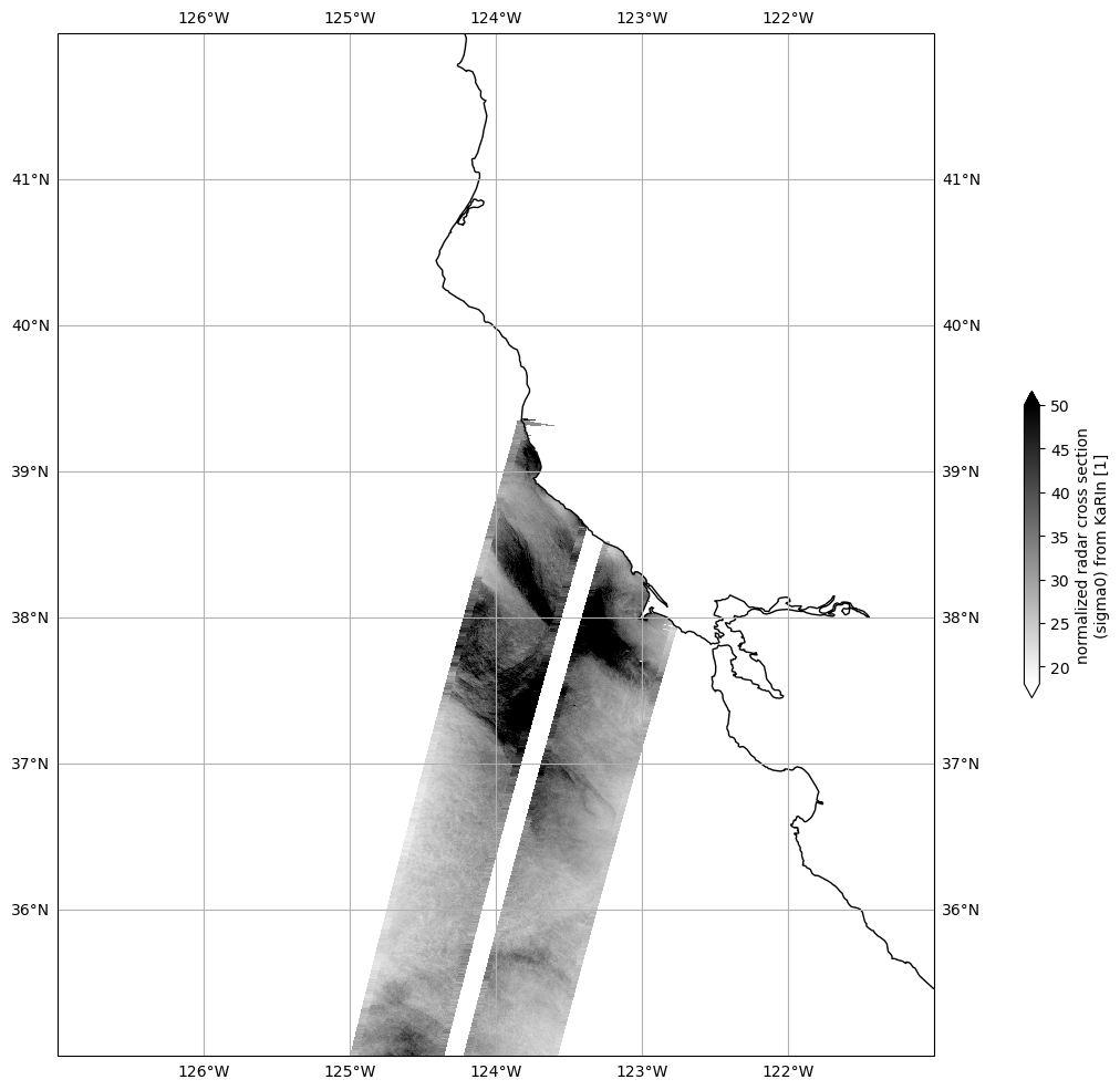
Plot Sigma 0
Mask invalid data
[24]:
for dss in ds_left, ds_right:
    dss["sig0_karin_2"] = dss.sig0_karin_2.where(dss.ancillary_surface_classification_flag==0)
    dss["sig0_karin_2"] = dss.sig0_karin_2.where(dss.sig0_karin_2 < 1e6)
    #dss["sig0_karin_2_log"] = 10*np.log10(dss["sig0_karin_2"])
Plot data
[30]:
plot_kwargs = dict(
    x="longitude",
    y="latitude",
    cmap="gray_r",
    vmin=5,
    vmax=40,
)

fig, ax = plt.subplots(figsize=(21, 12), subplot_kw=dict(projection=ccrs.PlateCarree()))
ds_left.sig0_karin_2.plot.pcolormesh(ax=ax, cbar_kwargs={"shrink": 0.3}, **plot_kwargs)
ds_right.sig0_karin_2.plot.pcolormesh(ax=ax, add_colorbar=False, **plot_kwargs)

ax.gridlines(draw_labels=True)
ax.coastlines()
ax.set_extent(localbox, crs=ccrs.PlateCarree())

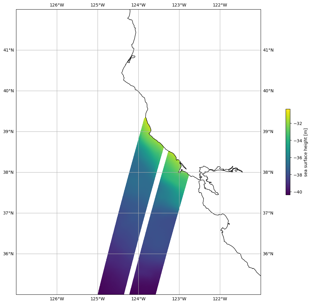
Plot SSHA
Mask invalid data
[26]:
for dss in ds_left, ds_right:
    dss["ssh_karin_2"] = dss.ssh_karin_2.where(dss.ancillary_surface_classification_flag==0)
    dss["ssh_karin_2"] = dss.ssh_karin_2.where(dss.ssh_karin_2_qual==0)
Plot data
[27]:
plot_kwargs = dict(
    x="longitude",
    y="latitude"
)

fig, ax = plt.subplots(figsize=(21, 12), subplot_kw=dict(projection=ccrs.PlateCarree()))
ds_left.ssh_karin_2.plot.pcolormesh(ax=ax, cbar_kwargs={"shrink": 0.3}, **plot_kwargs)
ds_right.ssh_karin_2.plot.pcolormesh(ax=ax, add_colorbar=False, **plot_kwargs)

ax.gridlines(draw_labels=True)
ax.coastlines()
ax.set_extent(localbox, crs=ccrs.PlateCarree())

[ ]:
