Subset SWOT LR L2 Unsmoothed data from AVISO’s THREDDS Data Server
This notebooks explains how to retrieve a geographical subset of unsmoothed (250-m) SWOT LR L2 data on AVISO’s THREDDS Data Server.
L2 Unsmoothed data can be explored at:
https://tds-odatis.aviso.altimetry.fr/thredds/catalog/dataset-l2-swot-karin-lr-ssh-validated/catalog.html
Note
Required environment to run this notebook:
xarray+numpymatplotlib+cartopygeopandas+shapelypyinterp+dask+numbasiphonpydapaltimetry.io: available here.
Warning
This tutorial shows how to retrieve datasets via the Opendap protocol of the AVISO’s THREDDS Data Server, that can be time consuming for large datasets. If you need to download large number of half orbits, please use the altimetry_downloader_aviso tool.
Tutorial Objectives
Crawl Aviso’s Thredds Data Server catalogue to find unsmoothed products with cycles/passes numbers using
siphonSubset data intersecting a geographical area using
xarray+pydapOpen data locally using
altimetry.ioVisualise data using
matplotlib
Import + code
# Install Cartopy with mamba to avoid discrepancies
# ! mamba install -q -c conda-forge cartopy
import warnings
warnings.filterwarnings('ignore')
import os
from siphon.catalog import TDSCatalog
from pathlib import Path
import re
import numpy as np
import xarray as xr
from xarray.backends import PydapDataStore
import requests as rq
import cartopy.crs as ccrs
import matplotlib.pyplot as plt
def _make_swot_regex(level, variant):
    return re.compile(
        rf"SWOT_{level}_LR_SSH_{variant}_(\d+)_(\d+)_.*\.nc$"
    )

SUBSETS = ["Basic", "Expert", "Unsmoothed", "WindWave", "Technical"]
def _crawl_swot_datasets_pruned(catalog, cycle_min, cycle_max, subset=None, level=0):
    """
    Optimised recursive crawl récursif for SWOT catalogs
    Args:
        subset: subset name. Possible values are: "Basic" | "Expert" | "Unsmoothed" | "WindWave" | "Technical"
        cycle_min: minimum cycle
        cycle_max: maximum cycle
    """
    indent = "  " * level
    print(f"{indent}Visiting catalog: {catalog.catalog_url}")

    for ds in catalog.datasets.values():
        yield ds

    for ref_name, ref in catalog.catalog_refs.items():
        m = re.search(r"cycle_(\d+)", ref_name)
        if m:
            cycle = int(m.group(1))
            if not (cycle_min <= cycle <= cycle_max):
                continue

        if subset is not None and ref_name in SUBSETS:
            if not ref_name == subset:
                continue

        try:
            subcat = ref.follow()
        except Exception as e:
            continue

        yield from _crawl_swot_datasets_pruned(subcat, cycle_min, cycle_max, subset, level=level+1)

def _swot_lr_dataset_filter(dataset, regex, cycle_min, cycle_max, half_orbits):
    if not dataset.access_urls or "OPENDAP" not in dataset.access_urls:
        return False

    if not dataset.url_path:
        return False

    filename = dataset.url_path.rsplit("/", 1)[-1]
    m = regex.match(filename)
    if m is None:
        return False

    cycle_number = int(m.group(1))
    pass_number = int(m.group(2))

    match = cycle_min <= cycle_number <= cycle_max and pass_number in half_orbits

    if match:
        print(f"Matched dataset: {filename}")

    return match

def retrieve_matching_datasets(url_catalogue, level, subset, cycle_min, cycle_max, half_orbits):
    """ Returns the list of datasets's Opendap URLS available in the catalogue, matching required level, subset, half_orbits and cycles range.
    Args:
        url_catalogue: the catalogue
        level: swot LR data level ("L2", "L3")
        subset: Swot LR data subset ("Basic", "Expert", "Unsmoothed", "WindWave", "Technical")
        cycle_min: minimum cycle
        cycle_max: maximum cycle
        half_orbits: list of passes numbers

    Returns:
        The list of matching dataset nodes.
    """
    regex = _make_swot_regex(level, subset)
    cat = TDSCatalog(url_catalogue)

    return [
        ds
        for ds in _crawl_swot_datasets_pruned(cat, cycle_min, cycle_max, subset)
        if _swot_lr_dataset_filter(ds, regex, cycle_min, cycle_max, half_orbits)
    ]
def open_dataset(dataset_url):
    """ Open the dataset at dataset_url.
    Args:
        dataset_url

    Returns:
        xr.Dataset
    """
    session = rq.Session()
    try:
        store = PydapDataStore.open(dataset_url, session=session, timeout=300, user_charset='UTF-8')
        return xr.open_dataset(store)
    except Exception as e:
        print(f"Something wrong with opendap url {dataset_url}: {e}")

def _open_dataset_coords(dataset_url):
    positions_url = dataset_url + '?' + ','.join(["/left/latitude", "/left/longitude", "/right/latitude", "/right/longitude"])
    ds_coords = open_dataset(positions_url)
    return ds_coords

def _get_indexes(ds, lon_range, lat_range):
    mask_left = ((ds["/left/longitude"] >= lon_range[0]) & (ds["/left/longitude"] <= lon_range[1]) &
    (ds["/left/latitude"] >= lat_range[0]) & (ds["/left/latitude"] <= lat_range[1]))

    mask_right = ((ds["/right/longitude"] >= lon_range[0]) & (ds["/right/longitude"] <= lon_range[1]) &
    (ds["/right/latitude"] >= lat_range[0]) & (ds["/right/latitude"] <= lat_range[1]))

    mask = (mask_left | mask_right).any('num_pixels')

    return np.where(mask)[0][0], np.where(mask)[0][-1]

def _build_dataset_groups(ds, left_vars, right_vars, attrs):
    # Clean group EXTRA_DIMENSION and variable attributes from global attributes
    attributes = dict(filter(
        lambda item: (
            item[0] not in ["_NCProperties"] and
            f"/left/" not in item[0] and
            f"/right/" not in item[0] and
            "EXTRA_DIMENSION" not in item[0]),
        attrs.items()))

    ds_left = ds[left_vars]
    ds_left.attrs.clear()
    ds_left.attrs["description"] = attributes.pop("left_description")
    ds_left = ds_left.rename({v: v.removeprefix('/left/') for v in left_vars})

    for var in list(ds_left.keys()):
        ds_left[var].encoding = {'zlib':True, 'complevel':5}

    ds_right = ds[right_vars]
    ds_right.attrs.clear()
    ds_right.attrs["description"] = attributes.pop("right_description")
    ds_right = ds_right.rename({v: v.removeprefix('/right/') for v in right_vars})

    for var in list(ds_right.keys()):
        ds_right[var].encoding = {'zlib':True, 'complevel':5}

    ds_root = ds[[]]
    ds_root.attrs = attributes

    return ds_root, ds_left, ds_right

def to_netcdf(ds_root, ds_left, ds_right, output_file):
    """ Writes the dataset to a netcdf file """
    ds_root.to_netcdf(output_file)
    ds_right.to_netcdf(output_file, group='right', mode='a')
    ds_left.to_netcdf(output_file, group='left', mode='a')

def _output_dir_prompt():
    answer = input('Do you want to write results to Netcdf files? [y/n]')
    if not answer or answer[0].lower() != 'y':
        return None
    return input('Enter existing directory:')

def load_subsets(matching_datasets, variables, lon_range, lat_range, output_dir=None):
    """ Loads subsets with variables and lon/lat range, and eventually write them to disk.
    Args:
        matching_datasets : the datasets nodes in the catalogue
        variables : the variables names
        lon_range : the longitude range
        lat_range : the latitude range
        output_dir : the output directory to write the datasets in separated netcdf files

    Returns:
        xr.Dataset
    """
    if not output_dir:
        output_dir = _output_dir_prompt()

    left_vars = [f'/left/{v}' for v in variables]
    right_vars = [f'/right/{v}' for v in variables]

    return [dataset for dataset in [_load_subset(dataset, left_vars, right_vars, lon_range, lat_range, output_dir) for dataset in matching_datasets] if dataset is not None]

def _load_subset(dataset_node, left_vars, right_vars, lon_range, lat_range, output_dir=None):
    output_file = None
    if output_dir:
        output_file = os.path.join(output_dir, f"subset_{dataset_node.name}")
        if os.path.exists(output_file):
            print(f"Subset {dataset_node.name} already exists. Reading it...")
            return xr.open_dataset(output_file)

    # Open the dataset only with coordinates
    dataset_url = dataset_node.access_urls["OPENDAP"]
    print(f"Reading {dataset_url}...")
    ds_positions = _open_dataset_coords(dataset_url)

    # Locate indexes of lines matching with the required geographical area
    try:
        idx_first, idx_last = _get_indexes(ds_positions, lon_range, lat_range)
    except IndexError:
        return None

    # Download subset
    dataset = open_dataset(dataset_url)

    ds = xr.merge([dataset[var][idx_first:idx_last] for var in left_vars+right_vars])
    print(f"Load intersection with selected area in dataset {dataset_node.name}: indices ({idx_first}, {idx_last})")
    ds.load()

    if output_file:
        ds_root, ds_left, ds_right = _build_dataset_groups(ds, left_vars, right_vars, ds_positions.attrs)
        to_netcdf(ds_root, ds_left, ds_right, output_file)
        print(f"File {output_file} created.")

    print('\n')
    return ds

def _interpolate_coords(ds):
    lon = ds.longitude
    lat = ds.latitude
    shape = lon.shape
    lon = np.array(lon).ravel()
    lat = np.array(lat).ravel()
    dss = xr.Dataset({
        'longitude': xr.DataArray(
                    data   = lon,
                    dims   = ['time']
                    ),
        'latitude': xr.DataArray(
                    data   = lat,
                    dims   = ['time'],
                    )
                },)
    dss_interp = dss.interpolate_na(dim="time", method="linear", fill_value="extrapolate")
    ds['longitude'] = (('num_lines', 'num_pixels'), dss_interp.longitude.values.reshape(shape))
    ds['latitude'] = (('num_lines', 'num_pixels'), dss_interp.latitude.values.reshape(shape))

def normalize_coordinates(ds):
    """ Normalizes the coordinates of the dataset : interpolates Nan values in lon/lat, and assign lon/lat as coordinates.
    Args:
        ds: the dataset

    Returns:
        xr.Dataset: the normalized dataset
    """
    _interpolate_coords(ds)
    return ds.assign_coords(
            {"longitude": ds.longitude, "latitude": ds.latitude}
        )
Parameters
Define the variables you want:
variables = ['latitude', 'longitude', 'time', 'sig0_karin_2', 'ancillary_surface_classification_flag', 'ssh_karin_2', 'ssh_karin_2_qual']
OPTIONAL Define existing output folder to save results:
output_dir= Path.home() / "TMP_DATA"
Define the url of the catalog from which you want to extract data
url_catalogue="https://tds-odatis.aviso.altimetry.fr/thredds/catalog/dataset-l2-swot-karin-lr-ssh-validated/PIC2/Unsmoothed/catalog.html"
level = 'L2'
subset = 'Unsmoothed'
Define the parameters needed to retrieve data:
geographical area
phase: 1day-orbit (Calval) / 21day-orbit (Science)
cycle min, max
list of half-orbits
Note
Passes matching a geographical area and period can be found using this tutorial
# California
lat_range = 35, 42
lon_range = 233, 239

#phase, cycle_min, cycle_max = "calval", 400, 600
phase, cycle_min, cycle_max = "science", 23, 24

half_orbits = [24, 317]
Area extraction
Gather datasets in the provided catalogue, matching the required cycles and half_orbits
matching_datasets = retrieve_matching_datasets(url_catalogue, level, subset, cycle_min, cycle_max, half_orbits)
'num datasets =', len(matching_datasets)
Visiting catalog: https://tds-odatis.aviso.altimetry.fr/thredds/catalog/dataset-l2-swot-karin-lr-ssh-validated/PIC2/Unsmoothed/catalog.xml
  Visiting catalog: https://tds-odatis.aviso.altimetry.fr/thredds/catalog/dataset-l2-swot-karin-lr-ssh-validated/PIC2/Unsmoothed/cycle_023/catalog.xml
Matched dataset: SWOT_L2_LR_SSH_Unsmoothed_023_024_20241023T014851_20241023T024018_PIC2_01.nc
Matched dataset: SWOT_L2_LR_SSH_Unsmoothed_023_317_20241102T130249_20241102T135416_PIC2_01.nc
  Visiting catalog: https://tds-odatis.aviso.altimetry.fr/thredds/catalog/dataset-l2-swot-karin-lr-ssh-validated/PIC2/Unsmoothed/cycle_024/catalog.xml
Matched dataset: SWOT_L2_LR_SSH_Unsmoothed_024_024_20241112T223355_20241112T232522_PIC2_01.nc
Matched dataset: SWOT_L2_LR_SSH_Unsmoothed_024_317_20241123T094755_20241123T103922_PIC2_01.nc
('num datasets =', 4)
matching_datasets
[SWOT_L2_LR_SSH_Unsmoothed_023_024_20241023T014851_20241023T024018_PIC2_01.nc,
 SWOT_L2_LR_SSH_Unsmoothed_023_317_20241102T130249_20241102T135416_PIC2_01.nc,
 SWOT_L2_LR_SSH_Unsmoothed_024_024_20241112T223355_20241112T232522_PIC2_01.nc,
 SWOT_L2_LR_SSH_Unsmoothed_024_317_20241123T094755_20241123T103922_PIC2_01.nc]
Subset data in the required geographical area
Warning
This operation may take some time : for each dataset, it downloads coordinates, calculates indices, loads subset and eventually writes it to netcdf file.
Set output_dir to None if you don’t want to write subsets to netcdf files.
datasets_subsets = load_subsets(matching_datasets, variables, lon_range, lat_range, output_dir)
Reading https://tds-odatis.aviso.altimetry.fr/thredds/dodsC/dataset-l2-swot-karin-lr-ssh-validated/PIC2/Unsmoothed/cycle_023/SWOT_L2_LR_SSH_Unsmoothed_023_024_20241023T014851_20241023T024018_PIC2_01.nc...
Load intersection with selected area in dataset SWOT_L2_LR_SSH_Unsmoothed_023_024_20241023T014851_20241023T024018_PIC2_01.nc: indices (21552, 25041)
File /home/atonneau/TMP_DATA/subset_SWOT_L2_LR_SSH_Unsmoothed_023_024_20241023T014851_20241023T024018_PIC2_01.nc created.


Reading https://tds-odatis.aviso.altimetry.fr/thredds/dodsC/dataset-l2-swot-karin-lr-ssh-validated/PIC2/Unsmoothed/cycle_023/SWOT_L2_LR_SSH_Unsmoothed_023_317_20241102T130249_20241102T135416_PIC2_01.nc...
Load intersection with selected area in dataset SWOT_L2_LR_SSH_Unsmoothed_023_317_20241102T130249_20241102T135416_PIC2_01.nc: indices (57902, 61397)
File /home/atonneau/TMP_DATA/subset_SWOT_L2_LR_SSH_Unsmoothed_023_317_20241102T130249_20241102T135416_PIC2_01.nc created.


Reading https://tds-odatis.aviso.altimetry.fr/thredds/dodsC/dataset-l2-swot-karin-lr-ssh-validated/PIC2/Unsmoothed/cycle_024/SWOT_L2_LR_SSH_Unsmoothed_024_024_20241112T223355_20241112T232522_PIC2_01.nc...
Load intersection with selected area in dataset SWOT_L2_LR_SSH_Unsmoothed_024_024_20241112T223355_20241112T232522_PIC2_01.nc: indices (21548, 25037)
File /home/atonneau/TMP_DATA/subset_SWOT_L2_LR_SSH_Unsmoothed_024_024_20241112T223355_20241112T232522_PIC2_01.nc created.


Reading https://tds-odatis.aviso.altimetry.fr/thredds/dodsC/dataset-l2-swot-karin-lr-ssh-validated/PIC2/Unsmoothed/cycle_024/SWOT_L2_LR_SSH_Unsmoothed_024_317_20241123T094755_20241123T103922_PIC2_01.nc...
Load intersection with selected area in dataset SWOT_L2_LR_SSH_Unsmoothed_024_317_20241123T094755_20241123T103922_PIC2_01.nc: indices (57900, 61394)
File /home/atonneau/TMP_DATA/subset_SWOT_L2_LR_SSH_Unsmoothed_024_317_20241123T094755_20241123T103922_PIC2_01.nc created.
Basic manipulations
Concatenate subsets
Visualize data on a pass
Open a pass dataset
from altimetry.io import AltimetryData, FileCollectionSource
alti_data = AltimetryData(
    source=FileCollectionSource(
        path=output_dir,
        ftype="SWOT_L2_LR_SSH",
        subset="Unsmoothed"
    ),
)
ds_left = alti_data.query_orbit(
    cycle_number=24,
    pass_number=317,
    backend_kwargs={"left_swath":True}
)
ds_left
<xarray.Dataset> Size: 34MB
Dimensions:                                (num_lines: 3494, num_pixels: 240)
Coordinates:
    latitude                               (num_lines, num_pixels) float64 7MB dask.array<chunksize=(3494, 240), meta=np.ndarray>
    longitude                              (num_lines, num_pixels) float64 7MB dask.array<chunksize=(3494, 240), meta=np.ndarray>
    time                                   (num_lines) datetime64[ns] 28kB dask.array<chunksize=(3494,), meta=np.ndarray>
Dimensions without coordinates: num_lines, num_pixels
Data variables:
    sig0_karin_2                           (num_lines, num_pixels) float32 3MB dask.array<chunksize=(3494, 240), meta=np.ndarray>
    ancillary_surface_classification_flag  (num_lines, num_pixels) float32 3MB dask.array<chunksize=(3494, 240), meta=np.ndarray>
    ssh_karin_2                            (num_lines, num_pixels) float64 7MB dask.array<chunksize=(3494, 240), meta=np.ndarray>
    ssh_karin_2_qual                       (num_lines, num_pixels) float64 7MB dask.array<chunksize=(3494, 240), meta=np.ndarray>
    cycle_number                           (num_lines) uint16 7kB 24 24 ... 24
    pass_number                            (num_lines) uint16 7kB 317 ... 317
Attributes:
description: Unsmoothed SSH measurement data and related information for...ds_right = alti_data.query_orbit(
cycle_number=24,
pass_number=317,
backend_kwargs={"right_swath":True}
)
ds_right
<xarray.Dataset> Size: 34MB
Dimensions:                                (num_lines: 3494, num_pixels: 240)
Coordinates:
    latitude                               (num_lines, num_pixels) float64 7MB dask.array<chunksize=(3494, 240), meta=np.ndarray>
    longitude                              (num_lines, num_pixels) float64 7MB dask.array<chunksize=(3494, 240), meta=np.ndarray>
    time                                   (num_lines) datetime64[ns] 28kB dask.array<chunksize=(3494,), meta=np.ndarray>
Dimensions without coordinates: num_lines, num_pixels
Data variables:
    sig0_karin_2                           (num_lines, num_pixels) float32 3MB dask.array<chunksize=(3494, 240), meta=np.ndarray>
    ancillary_surface_classification_flag  (num_lines, num_pixels) float32 3MB dask.array<chunksize=(3494, 240), meta=np.ndarray>
    ssh_karin_2                            (num_lines, num_pixels) float64 7MB dask.array<chunksize=(3494, 240), meta=np.ndarray>
    ssh_karin_2_qual                       (num_lines, num_pixels) float64 7MB dask.array<chunksize=(3494, 240), meta=np.ndarray>
    cycle_number                           (num_lines) uint16 7kB 24 24 ... 24
    pass_number                            (num_lines) uint16 7kB 317 ... 317
Attributes:
description: Unsmoothed SSH measurement data and related information for...Interpolate coordinates to fill Nan values in latitude and longitude, and assign them as coordinates.
ds_left = normalize_coordinates(ds_left)
ds_right = normalize_coordinates(ds_right)
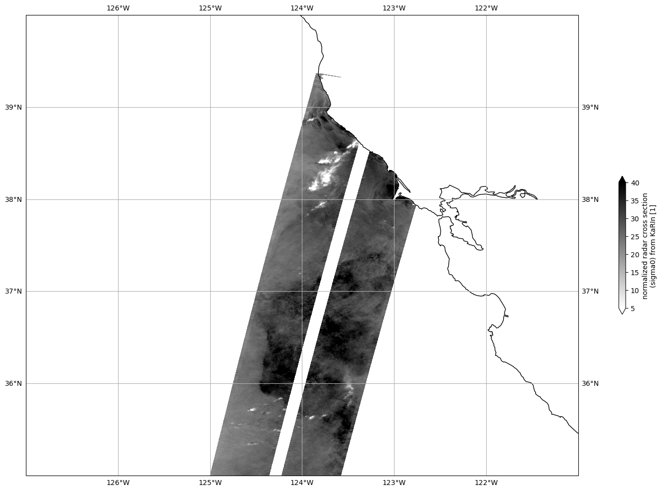
Plot Sigma 0
Mask invalid data
for dss in ds_left, ds_right:
    dss["sig0_karin_2"] = dss.sig0_karin_2.where(dss.ancillary_surface_classification_flag==0)
    dss["sig0_karin_2"] = dss.sig0_karin_2.where(dss.sig0_karin_2 < 1e6)
    #dss["sig0_karin_2_log"] = 10*np.log10(dss["sig0_karin_2"])
Plot data
plot_kwargs = dict(
    x="longitude",
    y="latitude",
    cmap="gray_r",
    vmin=5,
    vmax=40,
)

fig, ax = plt.subplots(figsize=(21, 12), subplot_kw=dict(projection=ccrs.PlateCarree()))
ds_left.sig0_karin_2.plot.pcolormesh(ax=ax, cbar_kwargs={"shrink": 0.3}, **plot_kwargs)
ds_right.sig0_karin_2.plot.pcolormesh(ax=ax, add_colorbar=False, **plot_kwargs)

ax.gridlines(draw_labels=True)
ax.coastlines()
ax.set_extent([-127, -121, 35, 40], crs=ccrs.PlateCarree())
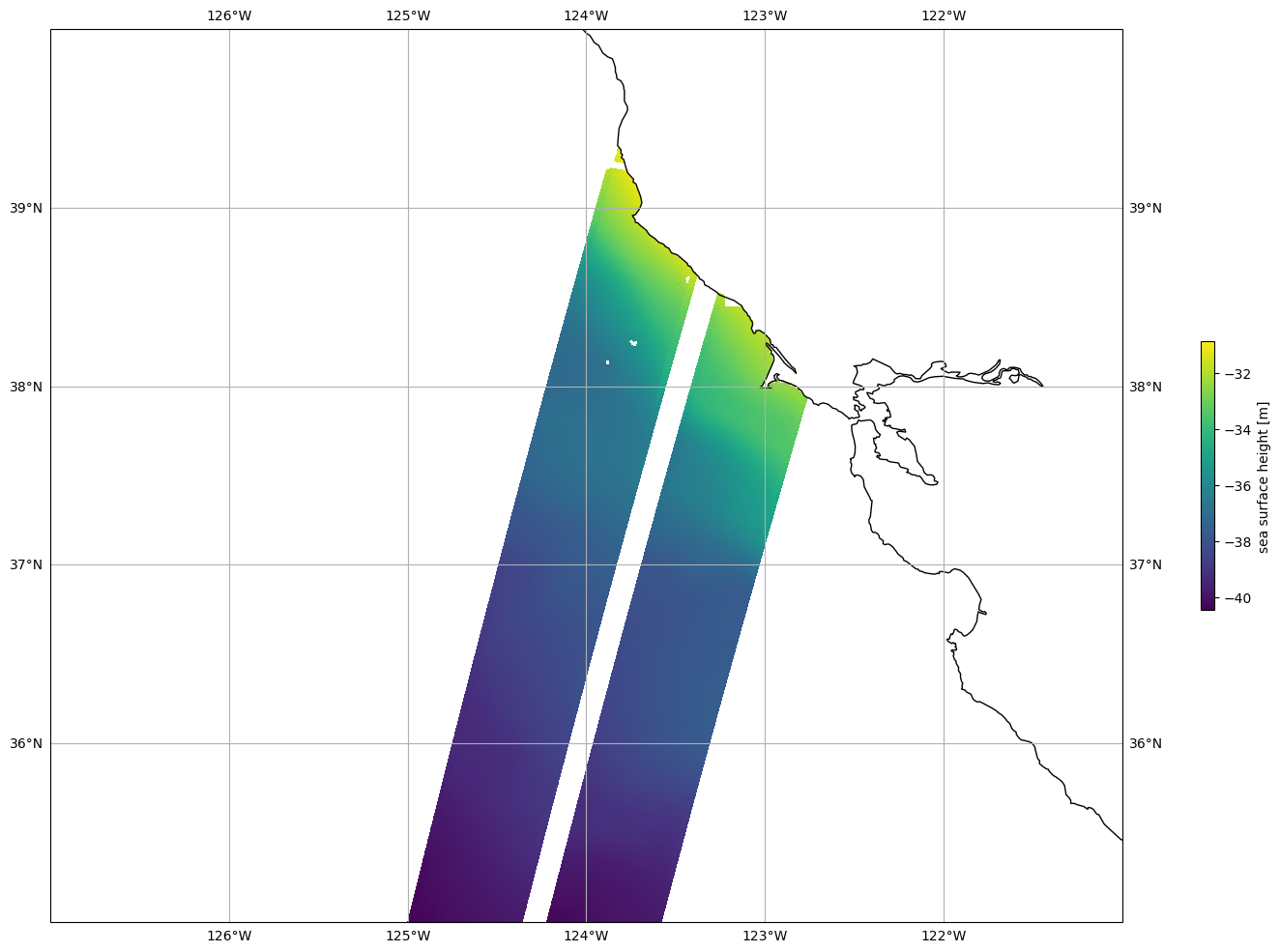
Plot SSHA
Mask invalid data
for dss in ds_left, ds_right:
    dss["ssh_karin_2"] = dss.ssh_karin_2.where(dss.ancillary_surface_classification_flag==0)
    dss["ssh_karin_2"] = dss.ssh_karin_2.where(dss.ssh_karin_2_qual==0)
Plot data
plot_kwargs = dict(
    x="longitude",
    y="latitude"
)

fig, ax = plt.subplots(figsize=(21, 12), subplot_kw=dict(projection=ccrs.PlateCarree()))
ds_left.ssh_karin_2.plot.pcolormesh(ax=ax, cbar_kwargs={"shrink": 0.3}, **plot_kwargs)
ds_right.ssh_karin_2.plot.pcolormesh(ax=ax, add_colorbar=False, **plot_kwargs)

ax.gridlines(draw_labels=True)
ax.coastlines()
ax.set_extent([-127, -121, 35, 40], crs=ccrs.PlateCarree())