V2.0.0 changes
Note
There is no Unsmoothed dataset for V2.0.0. The Unsmoothed dataset has been released under V2.0.1 following the resolution of minor issues. Please check the V2.0.1 changes
Basic, Expert and Unsmoothed
PIC/PGC blending
The PIC/PGC blending does not differ from the version 1 (see PIC/PGC blending).
Geophysical corrections
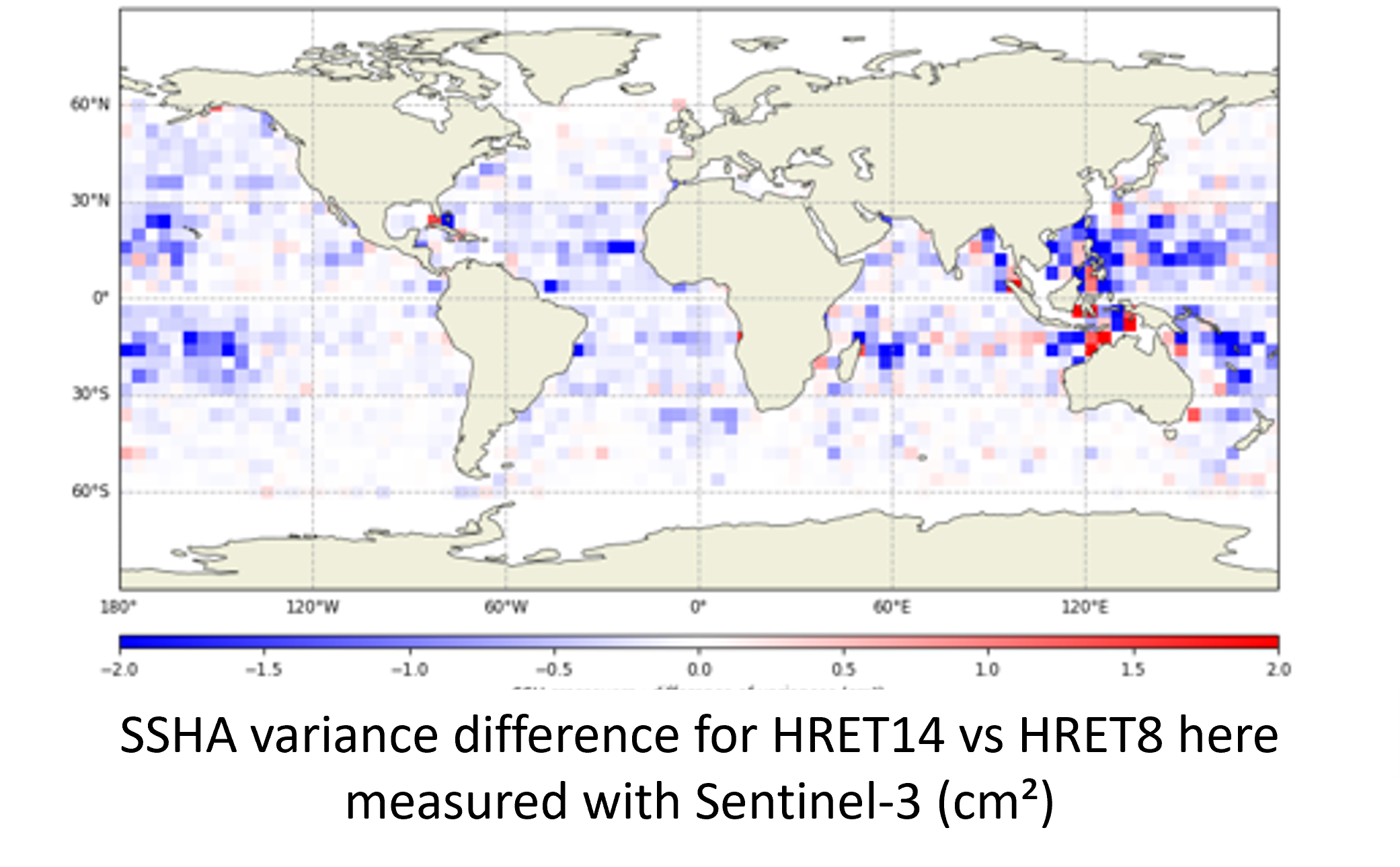
Internal tide model blend (HRET14/HRET8.1)
The internal tide correction is improved in v2.0 with the use of a blend solution of HRET14 & HRET8.1 model (Zaron, 2024). HRET14 resolves the coherent tides for 5 different tidal frequencies (M2, K1, S2, O1, N2) while HRET8.1 uses 4 tidal frequencies (M2, K1, S2, O1).The blend HRET solution is slightly more accurate than HRET 8.1 over most of the open ocean (3 mm RMS, locally 1 cm; Consistent numbers found with SWOT Nadir, SWOT Karin, Jason-3, Sentinel-3 and 6 missions). The gain is however not geographically homogeneous. Like HRET8.1, the blend solution is based on nadir altimetry and it does not correct for higher modes of IT, non linear waves, solitons, and non-stationary tides. The blend HRET solution is delivered in a dedicated variable of the L3 v2.0 products, allowing the user to uncorrect and replace it.
MDT bias
A negative 5cm offset was introduced in the MDT field model, and resulting ADT. This offset fixes known discrepancy between SWOT and other L3 products from CMEMS & DUACS. It was introduced in the CMEMS & DUACS production in 2014, following a change of the arbitrary altimeter reference period used ([1993, 1997] vs. [1993, 2012]).
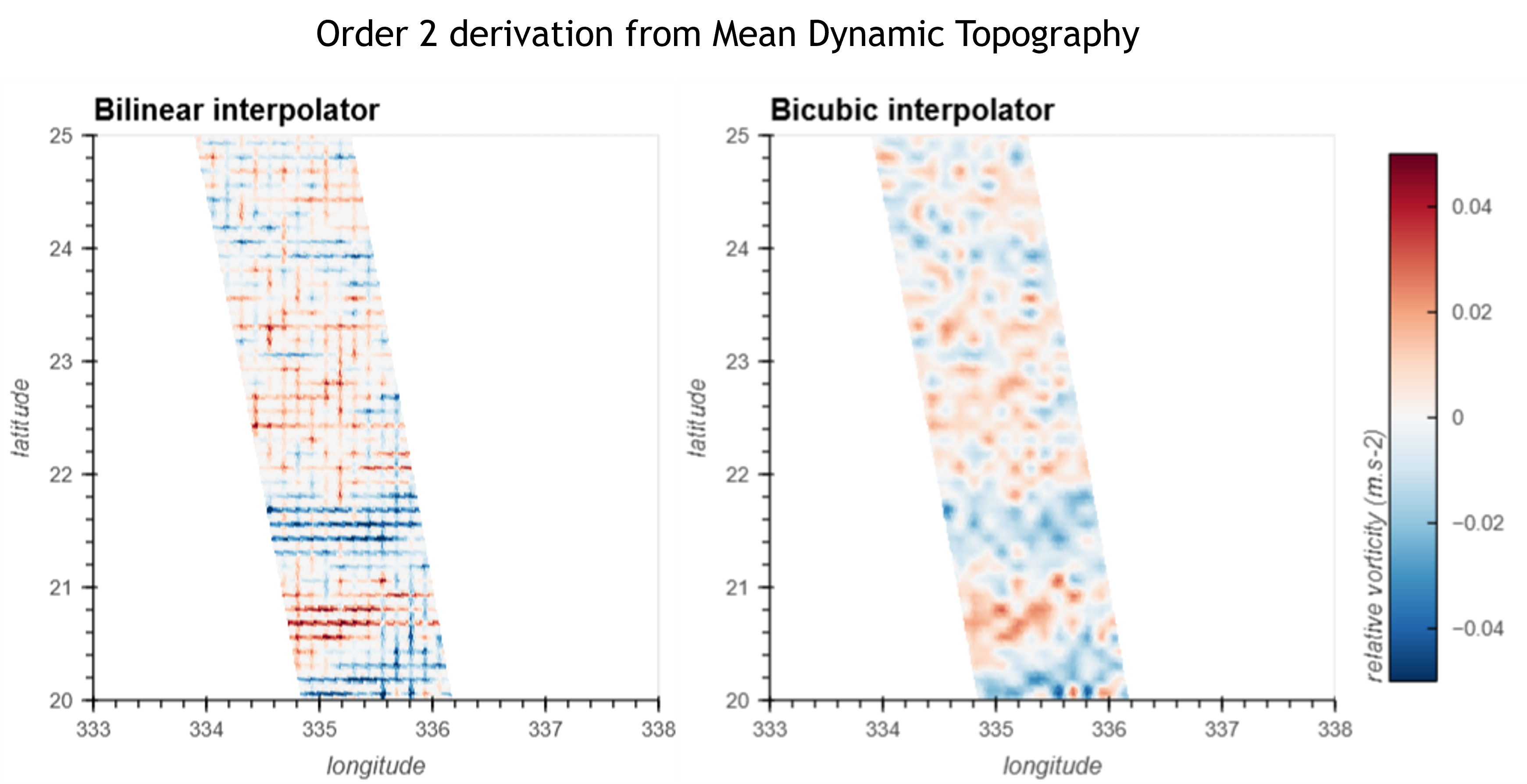
MDT bicubic interpolator
The Mean Dynamic Topography is computed from a static auxiliary data file. The interpolation method for regridding the auxiliary onto the swath grid in v1 was a bilinear interpolation. Computing the second order derivative from the interpolated MDT shows cross-shaped artifacts. To reduce these patterns, the v2 now interpolates the MDT using a bicubic interpolation method.
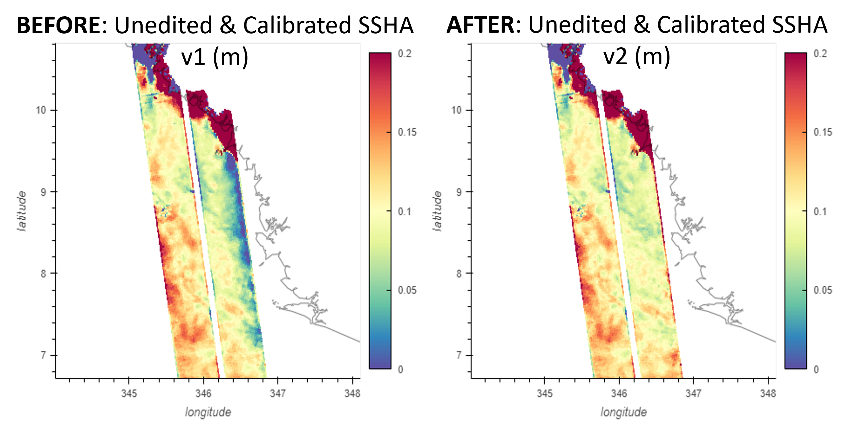
Sea state bias offset in polar transitions
The SSB2 correction of the L2 PIC/PGC product is used in L3 production. This solution is based on MFWAM model output that shows limitation of definition in polar and coastal areas. Consequently, a know offset of 10cm is introduced in SSB2 in these areas, impacting the resulting SSHA with introduction of net discontinuities. In L3 V2, the SSB2 correction is extrapolated towards 0 in polar areas in order to remove the SSH discontinuities that may limit polar studies (e.g. Figure 12). This was done assuming the in sea-ice leads SSB is close to zero (small waves), so we enforce continuous transition from open ocean to sea-ice leads. Nevertheless, this extrapolation does not yield a correct/geophysical SSB correction. This quick fix intends to remove only the SSB2 offset in a gradual way, but the SSHA remains biased (no wave height available in these regions = SSHA bias).
Flagging changes
Eclipse transition
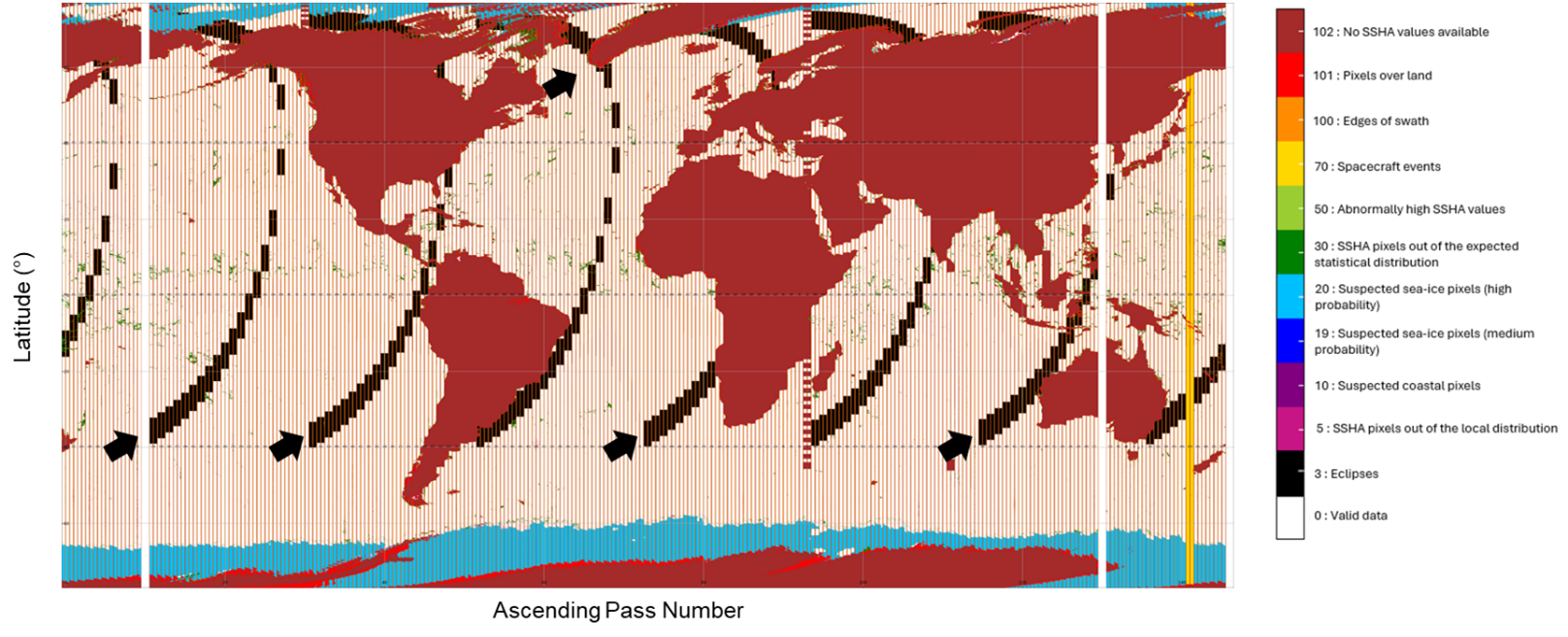
Eclipse transition segments are isolated from other SWOT mission events (e.g. maneuvers) & flagged with a specific value. The performance analyses from the L2 Project CalVal and L3 teams did not observe any degradation for these segments. Consequently, the SSHA is now provided during eclipse transitions, improving the coverage by 4%. The users of expert and unsmoothed products can choose to remove these segments by using the specific flag value.
Land-sea mask / Surface type
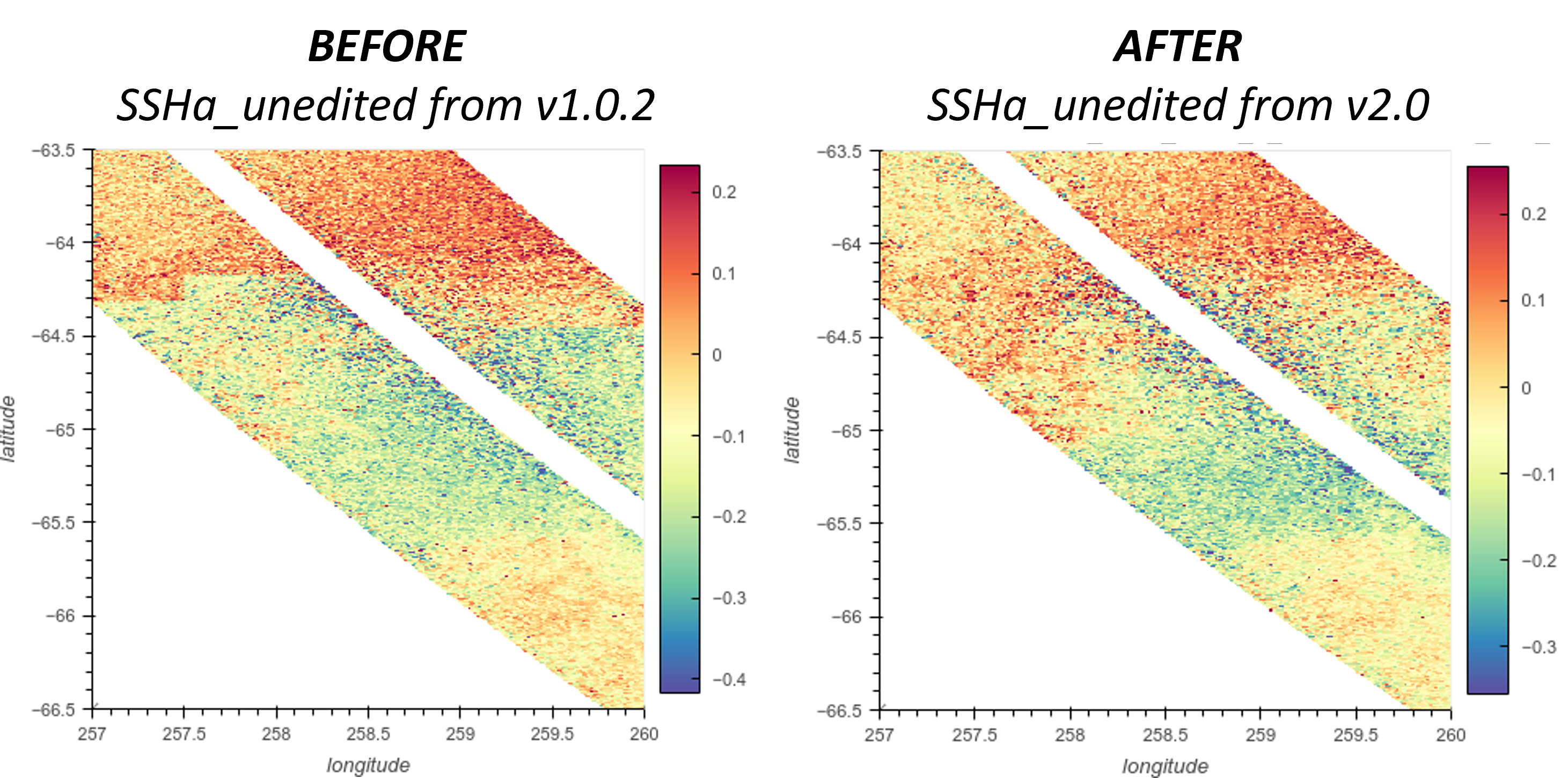
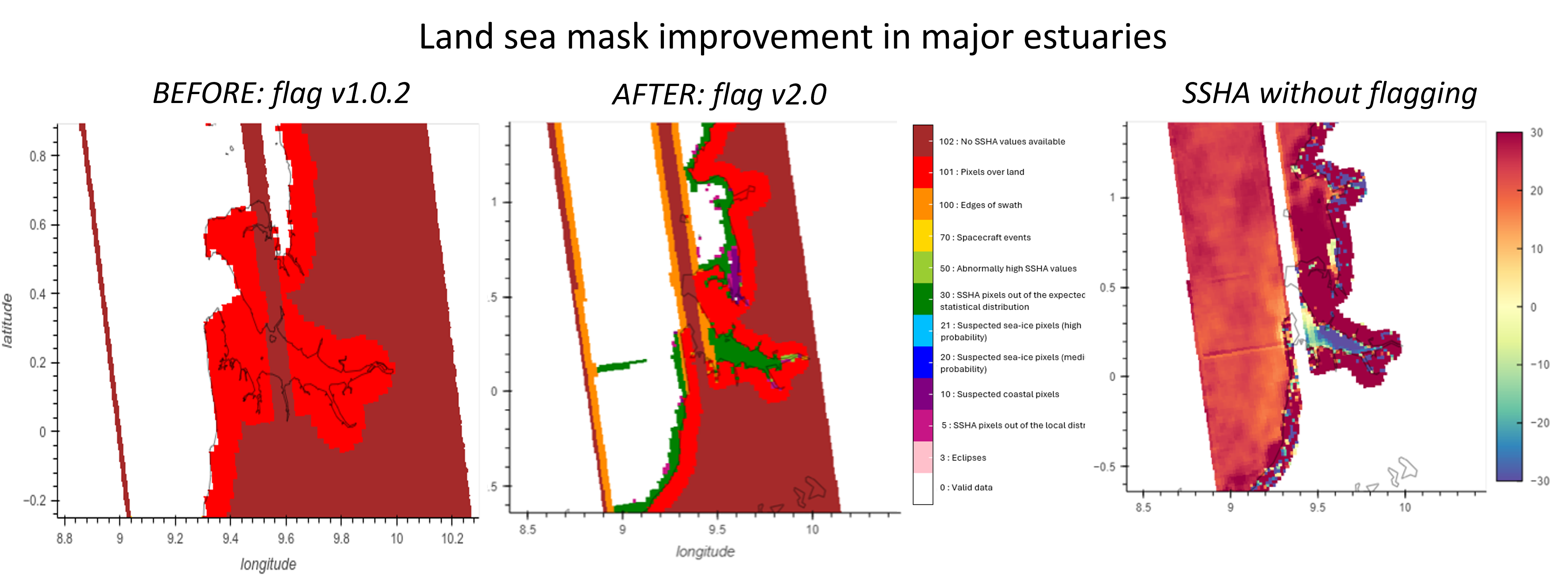
In V1.0, we introduced a mask that fixes most of the known L2 issues but shows some failures in the estuaries (refer to the change note). In V2.0 we now use a revised mask with manual processing of 43 major estuaries to retrieve them. The quality flag is updated consequently. Nevertheless, estuaries with no SSHA in the L2 cannot be retrieved in the L3 (known PIC/PGC issue, not related to land mask), and retrieved SSHA can be rejected with other statistical criteria.
Other changes
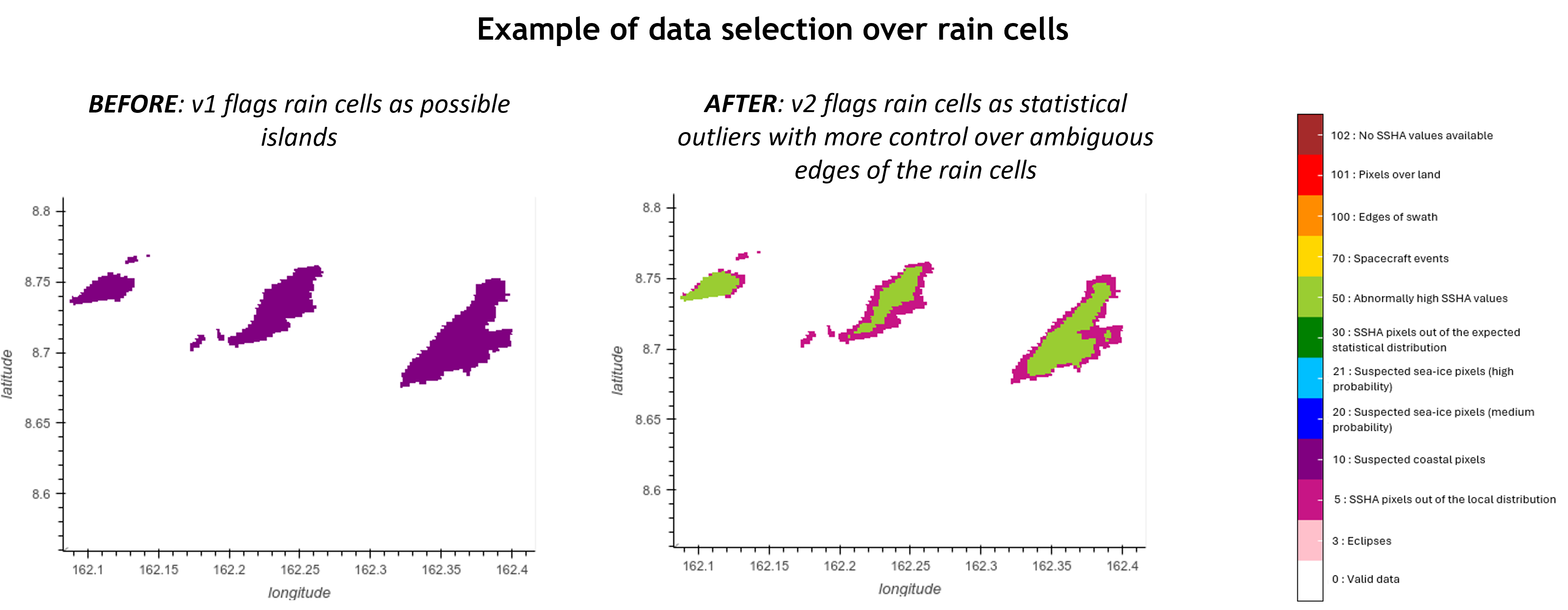
The selection flag algorithm was revisited to reduce the occurrence of ambiguous rejection criteria (e.g. rain vs coast), and to take into account areas better retrieved with revised L3 SSB2 (see previous section). In that last case, only pixels with an ice concentration higher than 60% and those on the edge of the polar ocean are flagged as “suspected sea-ice pixels” (flag 20)

The data selection sequence is also better integrated with the L3 calibration, improving the quality of the latest.
Product content
- Renamed variables
ssha->ssha_unfilteredssha_noiseless->ssha_filteredugosa->ugosa_filteredvgosa->vgosa_filtered
- New variables
internal_tidecontains the internal tide solution applied to all SSHA fieldsugosa_unfilteredandvgosa_unfilteredcontains the zonal and meridional geostrophic velocities anomalies derived fromssha_unfiltered. The field is very noisy so the user should apply a smoothing.
Basic and Expert
Calibration
The calibration in v1 was absorbing other geophysical error residuals (see the SWOTST 2024 Talk) and not just KaRIn systematic errors. The calibration algorithm and sequence was thus improved in v2 with the objective to reduce the leakage of ocean dynamical signal and to take into account improvements done on the data selection processing:
A large part of the data selection is now applied before calibration
Data eclipse transition segments are used in the calibration
A more sophisticated handling of the bias/linear/quadratic terms and the orbital harmonics VS broadband interpolators is introduced: fewer degrees of freedom are used in order to calibrate only what is absolutely needed and ignore uncalibrated error sources when calibration is not possible or desirable.
This results in better correction for the semi-enclosed / coastal / polar seas and Hydrology. On counterpart, more tidal, SSB and Wet troposphere residual signals may be observed in SSHA field.