Overview
The Level-3 (L3) products are formally part of the Science Team Project DESMOS and funded by the French Early Adopter Program (i.e. PIA). Those products are lightweight, simple, and usable out-of-the-box; moreover, Nadir altimeter & KaRIn measurements are displayed in one single image.
- The Value-added compared to SWOT L2 KaRIn (L2_LR_SSH) products are:
State of the art research-grade upgrades (incl. very recent & submitted papers)
Multi-mission calibration (SWOT is consistent with other altimeters)
Noise-mitigation for SSHA derivatives (experimental, AI-based)
Pre-made sophisticated editing procedure KaRIn and nadir instruments blended into a single image
L3 has new layers (optional) that can blend with L2 fields
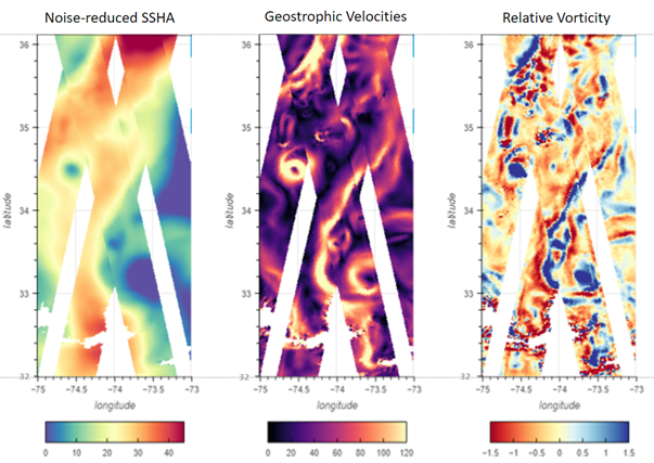
Example of SSHA (after noise reduction) (left), geostrophic velocities (middle) and relative vorticity (right) obtained with SWOT measurements contained in the SWOT L3 KaRIn ocean product
- 4 types of files are distributed: Basic, Expert, Technical and Unsmoothed
Basic L3_LR_SSH includes only SSHA (Sea Surface Height Anomaly) and mean dynamic topography (MDT) on the 2km KaRIn grid
Expert L3_LR_SSH includes the backscatter coefficient (sigma0), the mean sea surface (MSS) and geostrophic currents (absolute and anomalies) in addition to SSHA and mean dynamic topography (MDT). It also integrates algorithms, corrections and external models as separate layers. It is available on the 2km KaRIn grid
Technical L3_LR includes additional parameters and geophysical fields that may be of interest for certain applications or that provides an alternative solution to those used in the core (Basic/Expert) datasets. It is available on the 2 km KaRIn grid
Unsmoothed L3_LR_SSH includes the MSS, MDT and geostrophic currents (absolute and anomalies) in addition to the SSHA and MDT on the 250-m KaRIn native grid. Like the Expert subproduct, it also integrates a quality flag, corrections and external models as separate layers
Note
The Expert dataset includes all the Basic dataset content
Releases
Version |
Dataset |
Release date |
|---|---|---|
V3.0 |
Expert |
November 2025 |
Technical |
December 2025 |
|
V2.0.1 |
Expert |
March 2025 |
Unsmoothed |
||
V2.0.0 |
Expert |
27th January 2025 |
V1.0.2 |
Unsmoothed |
18th October 2024 |
Expert |
17th September 2024 |
|
V1.0.1 |
Unsmoothed |
28th June 2024 |
V1.0 |
Unsmoothed |
14th June 2024 |
Expert |
3rd June 2024 (daily)
13th May 2024
|
|
V0.3 |
Expert |
9th January 2024 |
Temporal coverage
The following table shows the temporal coverage of the L3_LR_SSH products. Coverage may differ between the Expert and Unsmoothed datasets. Some holes in the time series are due to missing L2_LR_SSH data or constraints on the Level-3 production. See the associated version notes for more details.
Basic/Expert/Technical |
|
|---|---|
CalVal phase
(1-day)
|
C474/T003 - C578/T004
28th March 2023 – 10th July 2023
|
Science phase
(21-days)
|
C001/T149 - now
26th July 2023 – now
|
Basic/Expert |
Unsmoothed |
|
|---|---|---|
CalVal phase
(1-day)
|
C474/T003 - C578/T004
28th March 2023 – 10th July 2023
|
C474/T003 - C578/T004
28th March 2023 – 10th July 2023
|
Science phase
(21-days)
|
C001/T149 - C041/T452
26th July 2023 – 17th November 2025
|
C001/T149 - C029/T379
26th July 2023 – 9th March 2025
|
Basic/Expert |
Unsmoothed |
|
|---|---|---|
CalVal phase
(1-day)
|
C474/T003 - C578/T004
28th March 2023 – 10th July 2023
|
Not Applicable |
Science phase
(21-days)
|
C001/T149 - C029/T127
26th July 2023 – 28th February 2025
|
Not Applicable |
Basic/Expert |
Unsmoothed |
|
|---|---|---|
CalVal phase
(1-day)
|
C474/T003 - C578/T004
28th March 2023 – 10th July 2023
|
C474/T003 - C578/T004
28th March 2023 – 10th July 2023
|
Science phase
(21-days)
|
C001/T149 - C027/T091
26th July 2023 – 16th January 2025
|
C001/T149 - C016/T554
26th July 2023 – 17th June 2024
|
Basic/Expert |
Unsmoothed |
|
|---|---|---|
CalVal phase
(1-day)
|
C474/T003 - C578/T004
28th March 2023 – 10th July 2023
|
C474/T003 - C578/T004
28th March 2023 – 10th July 2023
|
Science phase
(21-days)
|
C001/T149 - C017/T557
26th July 2023 – 8th July 2024
|
C001/T149 - C006/T584
6th September 2023 – 23th November 2023
|
Basic/Expert |
Unsmoothed |
|
|---|---|---|
CalVal phase
(1-day)
|
C474/T007 - C578/T002
29th March 2023 – 10th July 2023
|
N/A |
Science phase
(21-days)
|
C003/T170 - C006/T544
6th September 2023 – 21th November 2023
|
N/A |
Data policy and condition of use
The SWOT L3 KaRIn ocean product is available free of charge for scientific studies and commercial activities.
How to cite
Publications should include the following statement in the Acknowledgments
- Citation Basic L3_LR_SSH
“The SWOT_L3_LR_SSH product, derived from the L2 SWOT KaRIn Low rate ocean data products (L2_LR_SSH) (NASA/JPL and CNES), is produced and made freely available by AVISO and DUACS teams as part of the DESMOS Science Team project”. AVISO/DUACS., 2023. SWOT Level-3 SSH Basic (v3.0) [Data set]. CNES. https://doi.org/10.24400/527896/A01-2023.017
- Citation Expert L3_LR_SSH
“The SWOT_L3_LR_SSH product, derived from the L2 SWOT KaRIn low rate ocean data products (L2_LR_SSH) (NASA/JPL and CNES), is produced and made freely available by AVISO and DUACS teams as part of the DESMOS Science Team project”. AVISO/DUACS, 2023. SWOT Level-3 SSH Expert (v3.0) [Data set]. CNES. https://doi.org/10.24400/527896/A01-2023.018
- Citation Technical L3_LR_SSH
“The SWOT_L3_LR_SSH product, derived from the L2 SWOT KaRIn low rate ocean data products (L2_LR_SSH) (NASA/JPL and CNES), is produced and made freely available by AVISO and DUACS teams as part of the DESMOS Science Team project”. AVISO/DUACS, 2023. SWOT Level-3 SSH Technical (v3.0) [Data set]. CNES. https://doi.org/10.24400/527896/A01-2025.009
- Citation Unsmoothed L3_LR_SSH
“The SWOT_L3_LR_SSH product, derived from the L2 SWOT KaRIn low rate ocean data products (NASA/JPL and CNES), is produced and made freely available by AVISO and DUACS teams as part of the DESMOS Science Team project”. AVISO/DUACS, 2024. SWOT Level-3 KaRIn Low Rate SSH Unsmoothed (v2.0.1) [Data set]. CNES. https://doi.org/10.24400/527896/A01-2024.003
Bibliography
Arbic, Brian K., Robert B. Scott, Dudley B. Chelton, James G. Richman, et Jay F. Shriver. 2012. « Effects of Stencil Width on Surface Ocean Geostrophic Velocity and Vorticity Estimation from Gridded Satellite Altimeter Data ». Journal of Geophysical Research: Oceans 117 (C3): 2011JC007367. https://doi.org/10.1029/2011JC007367.
Cartwright, D. E., et Anne C. Edden. 1973. « Corrected Tables of Tidal Harmonics ». Geophysical Journal International 33 (3): 253-64. https://doi.org/10.1111/j.1365-246X.1973.tb03420.x.
Cartwright, D. E., et R. J. Tayler. 1971. « New Computations of the Tide-generating Potential ». Geophysical Journal International 23 (1): 45-73. https://doi.org/10.1111/j.1365-246X.1971.tb01803.x.
Charayron, R., P. Schaeffer, M. Ballaritta, et al. 2025. « Blending Data from SWOT KaRIn Science Phase and 30 Years of Nadir Altimetry to Improve Mean Sea Surface Models ». Oral presentation. EGU General Assembly 2025, Vienna, Austria, April 30. https://meetingorganizer.copernicus.org/EGU25/EGU25-8570.html.
Chou, Min-Yang, Jia Yue, Jack Wang, J. D. Huba, Mostafa El Alaoui, Maria M. Kuznetsova, Lutz Rastätter, et al. 2023. « Validation of Ionospheric Modeled TEC in the Equatorial Ionosphere During the 2013 March and 2021 November Geomagnetic Storms ». Space Weather 21 (6): e2023SW003480. https://doi.org/10.1029/2023SW003480.
Desai, Shailen, John Wahr, et Brian Beckley. 2015. « Revisiting the Pole Tide for and from Satellite Altimetry ». Journal of Geodesy 89 (12): 1233-43. https://doi.org/10.1007/s00190-015-0848-7.
Dibarboure et al., 2024, SWOT ST, SWOT Level-3 Overview and link with L2 products
Jousset, S., et S. Mulet. 2020. « New Mean Dynamic Topography of the Black Sea and Mediterranean Sea from altimetry, gravity and in-situ data ». Link to OSTST presentation
Jousset, S., S. Mulet, John Wilkin, Eric Greiner, G Dibarboure, et N Picot. 2022. « New global Mean Dynamic Topography CNES-CLS-22 combining drifters, hydrological profiles and High Frequency radar data”, OSTST 2022 ». https://doi.org/10.24400/527896/a03-2022.3292.
Jousset, Solène, Sandrine Mulet, Eric Greiner, et al. 2025. « New Global Mean Dynamic Topography CNES-CLS-22 Combining Drifters, Hydrography Profiles and High Frequency Radar Data ». ESS Open Archive, online preview. https://doi.org/10.22541/essoar.170158328.85804859/v2.
Laloue, A, P Veillard, P Schaeffer, M-I Pujol, O. Andersen, D Sandwell, A Delepoulle, G Dibarboure, et Y Faugere. 2024. « Merging recent Mean Sea Surface into a 2023 Hybrid model (from Scripps, DTU, CLS and CNES) ».
Loren Carrère, Florend Lyard, Mathilde Cancet, Damien J. Allain, Ergane Fauchet, Mei-Ling Dabat, Michel Tchilibou, Ramiro Ferrari, et Yannice Faugère. 2023. « The new FES2022 Tidal atlas. Presented at the 2023 SWOT Science Team meeting (Toulouse). Available online (last access: 19 April 2024): https://doi.org/10.24400/527896/a03-2022.3287 ».
Lyard, F., L Carrere, M-L Dabat, M Tchilibou, E Fouchet, Y Faugere, G Dibarboure, et N Picot. 2023. « Barotropic correction for SWOT: FES2022 and DAC ». Link to SWOT-ST meeting, Toulouse
Picard, Bruno, Aurélien Colin, Aurélien Husson, et Gérald Dibarboure. 2025. The Effects of Rain on a Ka-Band Swath Altimeter: Lessons Learned from the SWOT Mission. April 10. https://eartharxiv.org/repository/view/8950/.
Ray, R. D. 2025. « Documentation for Goddard Ocean Tide Solution GOT5: Global Tides from Multimission Satellite Altimetry”. NASA TM-20250002085, Goddard Space Flight Center, Greenbelt, Maryland, USA ». https://science.gsfc.nasa.gov/sed/content/uploadFiles/publication_files/GOT5-TechMemo.pdf.
Schaeffer, P., M-I Pujol, P Veillard, Y Faugere, Q Dagneaux, G Dibarboure, et N Picot. 2023. « The CNES CLS 2022 Mean Sea Surface: Short Wavelength Improvements from CryoSat-2 and SARAL/AltiKa High-Sampled Altimeter Data ». Remote Sensing 15 (11): 2910. https://doi.org/10.3390/rs15112910.
Tchilibou, Michel, Simon Barbot, Loren Carrere, Ariane Koch-Larrouy, Gérald Dibarboure, et Clément Ubelmann. 2025. « M2 Monthly and Annual Mode 1 and Mode 2 Internal Tide Atlases from Altimetry Data and MIOST: Focus on the Indo-Philippine Archipelago and the Region off the Amazon Shelf ». EGUsphere, January 7, 1-21. https://doi.org/10.5194/egusphere-2024-3947.
Tran, N. 2019. « Rapport Annuel d’activité SALP - Activité SSB ».
Tranchant, Yann-Treden, Benoit Legresy, Annie Foppert, Beatriz Pena-Molino, and Helen Elizabeth Phillips. 2025. « SWOT reveals fine-scale balanced motions and dispersion properties in the Antarctic Circumpolar Current ». ESS Open Archive, online preview. https://doi.org/10.22541/essoar.173655552.25945463/v1.
Ubelmann, Clément, Loren Carrere, Chloé Durand, et al. 2022. « Simultaneous Estimation of Ocean Mesoscale and Coherent Internal Tide Sea Surface Height Signatures from the Global Altimetry Record ». Ocean Science 18 (2): 469-81. https://doi.org/10.5194/os-18-469-2022.
Zaron E. et Elipot S. 2024. « Estimates of Baroclinic Tidal Sea Level and Currents from Lagrangian Drifters and Satellite Altimetry ». J. Atmoph. and Ocean. Tech.
Zaron, Edward D. 2019. « Baroclinic Tidal Sea Level from Exact-Repeat Mission Altimetry ». Journal of Physical Oceanography 49 (1): 193-210. https://doi.org/10.1175/JPO-D-18-0127.1.